INDIAN ARMED FORCES CHIEFS ON OUR RELENTLESS AND FOCUSED PUBLISHING EFFORTS

The insightful articles, inspiring narrations and analytical perspectives presented by the Editorial Team, establish an alluring connect with the reader. My compliments and best wishes to SP Guide Publications.

"Over the past 60 years, the growth of SP Guide Publications has mirrored the rising stature of Indian Navy. Its well-researched and informative magazines on Defence and Aerospace sector have served to shape an educated opinion of our military personnel, policy makers and the public alike. I wish SP's Publication team continued success, fair winds and following seas in all future endeavour!"

Since, its inception in 1964, SP Guide Publications has consistently demonstrated commitment to high-quality journalism in the aerospace and defence sectors, earning a well-deserved reputation as Asia's largest media house in this domain. I wish SP Guide Publications continued success in its pursuit of excellence.


- MoD initiates comprehensive review of Defence Acquisition Procedure 2020, pushes for defence reforms
- G7: The Swansong
- Kalinga Connect: South Asia to Polynesia
- Advanced MRSAM for India for a greater firepower
- Must Credit DRDO for Operation Sindoor, now what is next for defence R&D?
- Operation Sindoor | Day 2 DGMOs Briefing
- Operation Sindoor: Resolute yet Restrained
Unmanned
Blue-Water Unmanned Aerial Vehicles
The Indian Army and Indian Navy have issued a request for proposal (RFP) for 95 mini-UAVs. Companies which may be involved are Israel’s Bluebird Aero Systems, Innocon and others. Bluebird Aero Systems makes UAVs like MicroB for urban use, SkyliteB for tactical ISR for infantry tactical teams/special units, Boomrang for long-endurance missions and Blueeye for civilian application.
Maritime domain domination is a very important aspect of naval operations for which maritime surveillance is an essential ingredient. Maritime surveillance is a complex business as it involves sub-surface, surface and air surveillance. The area of interest over the oceans is also very large, which is compounded by the inherent strategic role of the navy. So far all surveillance platforms were manned but with the development of unmanned systems, unmanned aerial vehicles (UAVs) have assumed an important part of this role. Adaption of shore-based UAVs for naval role was comparatively easy but the challenge was to develop ship-based UAVs which can operate from ships in all conditions. Common applications of UAV platforms are for reconnaissance, surveillance, intelligence gathering and targeting using a combination of infrared/optical sensor and a laser target designator. The US also has armed UAVs called unmanned combat aerial vehicles (UCAVs) and have used them in Iraq, and now in Afghanistan and Pakistan quite extensively. Some additional roles which could be assigned could be:
- Search and rescue, as amply proved during the tsunami search operations in Andaman and Nicobar Islands. The UAV would home in on an emergency beacon and focus on that area for information.
- It could carry a common data link and serve as a radio/data relay platform.
- Can enable a leap forward in payload sensor capability for naval surface fire.
- Provide real-time battle damage assessment.
The US Navy has taken the lead in this respect and started programmes both for rotary- and fixed-wing UAVs with the aim of acquiring cost-effective intelligence, surveillance and reconnaissance (ISR) capability. The UAVs were to operate from ships including littoral ships, aircraft carriers and are also shore-based. This has lead to the development of UAVs like Fire Scout, Scan Eagle, Picador and Eagle Eye. The US Navy is going to take a monumental leap in UAV capability with Northrop Grumman’s X-47B UCAV and MQ-4C Triton for maritime patrolling and reconnaissance.
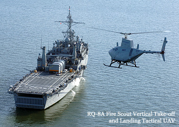
Fire Scout RQ-8
RQ-8A: The US Navy was looking for a vertical take-off and landing tactical UAV (VTUAV) to replace the RQ-2 Pioneer and Northrop Grumman’s Fire Scout was selected in February 2000. The first production model, which flew in May 2000, was designated RQ-8A and based on the Schweizer Model 330SP manned light helicopter.
RQ-8B: Northrop Grumman proposed an improved version called Sea Scout MQ-8B with a four-blade rotor version for longer endurance and enhanced payload capability for missiles. In January 2004, the MQ-8B was selected by the US Army for its future combat system unmanned aerial system requirement. The US Navy then selected the MQ-8B to support its littoral combat ships and the US Army also selected it for their tactical requirement. It was also redesignated as MQ-8B to indicate its multi-role capability. It was also selected for the US Marines.
MQ-8B: Fire Scout has the ability to autonomously take-off and land on any aviation-capable warship and on unprepared landing areas. It can carry out surveillance; locate, track and designate targets, and provide accurate targeting data to strike aircraft, helicopters and ships. It is equipped with a global positioning system (GPS)-based navigation system for autonomous operations and the ground control station can control three UAVs simultaneously.
The four-blade main rotor takes the gross take-off weight to 3,150 pounds (1,430 kg) with payloads of up to 700 pounds (320 kg), for short-range missions. It can have a variety of payloads depending on the role like the current sensor configuration of a day/night turret with a laser target designator, tactical synthetic aperture radar with moving target indicator capability, a multispectral sensor, a module, the target acquisition minefield detection system and the tactical common data link. The Fire Scout is ideally suited for littoral operations. It has a maximum speed of 115 knots (213 km/h)+, cruising speed of 110 knots (200 km/h), combat radius of 110 nm (203.7 km) plus five plus hours on station, endurance of eight hours and a service ceiling of 20,000 ft (6,100 m). In September 2009, the Navy announced the first deployment of the MQ-8B aboard USS McInerney, a guidedmissile frigate. In May 2011, three MQ-8s were deployed for northern Afghanistan for intelligence surveillance reconnaissance (ISR), a mission which has been extended by another year and have returned for antipiracy operations during August. The stub wing design enables housing for armament and with the addition of radar, automatic identification system and weapons; MQ-8B can provide many applications currently provided by SH-60B. A weaponised version is being developed by Northrop Grumman with an advanced precision kill weapon system laser-guided 70mm rocket which is likely to be ready by 2013.
MQ-8C Fire-X: During May 2010, Northrop Grumman announced plans to fly a modified Bell 407 helicopter with autonomous controls of MQ-8B, designated Fire-X to demonstrate an unmanned cargo resupply capability. The first demonstration flight took place during December 2010. Subsequently, the US Navy gave a contract in April 2012 to Northrop Grumman for the development and building MQ-8C for its naval special operations forces.
ScanEagle: In 2000, Insitu Inc. announced the development of the Sea-Scan naval UAV which was capable of launch and recovery from board a ship. In 2002, Boeing had an agreement with Insitu to develop the ScanEagle UAV which was successfully launched in 2002.
ScanEagle’s missions included ISR, special services operation, escort operations, sea-lane and convoy protection, protection of high-value and secure installations and high-speed voice, and video and data communications relay. In July 2004, the US Marine Corps contracted for two ScanEagles to be deployed in Iraq. The US Navy contracted in April 2005 for ScanEagles to be deployed on-board 15 destroyers and dock-landing ships. ScanEagle was very successful and by 2009 it had crossed 1,500 ship-board recoveries and clocked over 50,000 combat flight hours in Iraq. It is also in service with the Australian Army. In September 2008, Boeing acquired Insitu Inc. A night version was made in 2009, called NightEagle. The ScanEagle system also has been used to support the UK Ministry of Defence’s joint UAV experimentation programme through an industry team that includes Thales, QinetiQ and Boeing.
Performance: ScanEagle has a range of 1,500 km and an endurance of more than 28 hours. The air vehicle can operate at speeds between 80 km/h and 126 km/h and the cruise speed is 90 km/h in level flight. The vehicle achieves a maximum rate of climb of 150 m/min to a maximum altitude of 4,880 metres (16,000 ft). The longest flight achieved by ScanEagle fitted with the automobile gasoline engine is 22 hours and 10 minutes and fitted with heavy fuel engine is 28 hours 44 minutes using JP5.
Control and navigation: The ground control station has two operator consoles and can control up to eight UAVs. The control and navigation system provides the ScanEagle with waypoint navigation using differential GPS navigation, autonomous object tracking and autonomous in-flight route mapping. The ScanEagle is equipped with a Guidestar 111 control and navigation sensor supplied by Athena Technologies Inc.
Sensors: The ScanEagle is made of five field-replaceable major modules. The nose of the ScanEagle vehicle houses a gimbaled and inertial stabilised turret which can be fitted with a DRS E6000 high resolution un-cooled thermal imager module. The other sensors include electro-optical and infrared sensors, biological and chemical sensors, laser designators, and a magnetometer for locating and identifying magnetic abnormalities. An upgraded Block D variant houses a new sensor turret which accommodates larger cameras. During January 2007, the US Air Force initiated a study for the fitment of a sniper gun fire detection and location system supplied by Shot Spotter Inc., which provides enhanced protection for military convoys and military bases against sniper fire.
In August 2008, successful tests were carried out with a short-wave infrared camera supplied by Goodrich sensors. Fitting of radar are also being explored. During January 2008, Boeing flight-tested the NanoSAR synthetic aperture radar of ImSAR, which weighs only 2 lb and claims to be the world’s smallest SAR. Boeing has carried out tests of the biological combat assessment system on-board ScanEagle.
Take-off and recovery: ScanEagle is not fitted with landing gear. It is catapult launched from a pneumatically operated launcher with a launch velocity of 25 m/s. The recovery system is based on the proven SkyHook recovery system which was developed by Insitu for SeaScan UAV. The SkyHook retrieval system uses an arresting or snagging line suspended from a 15.2 m boom. The air vehicle is flown directly to approach the snagging line and a hook installed in the air vehicle’s wingtip is caught on the line. An alternative conventional land recovery can be used on an open area of about 30 m by 200 m.
SP's Naval Forces - CURRENT ISSUE