


The insightful articles, inspiring narrations and analytical perspectives presented by the Editorial Team, establish an alluring connect with the reader. My compliments and best wishes to SP Guide Publications.
"Over the past 60 years, the growth of SP Guide Publications has mirrored the rising stature of Indian Navy. Its well-researched and informative magazines on Defence and Aerospace sector have served to shape an educated opinion of our military personnel, policy makers and the public alike. I wish SP's Publication team continued success, fair winds and following seas in all future endeavour!"

Since, its inception in 1964, SP Guide Publications has consistently demonstrated commitment to high-quality journalism in the aerospace and defence sectors, earning a well-deserved reputation as Asia's largest media house in this domain. I wish SP Guide Publications continued success in its pursuit of excellence.
Coastal Security
Over the past decade, India has begun to address the maritime threats and challenges it faces with the installation of radar systems. But there are significant gaps in the surveillance coverage and the means to integrate local, regional and national information.
The world’s economy sails on the oceans as 95 per cent of the goods sold and the majority of the world’s oil and gas move on them. The oceans also provide seafood, minerals, oil and gas. The world is connected through the ocean floors by fibre-optic cables which provide global communications. Due to the economic importance of the oceans in a nation’s development, the United Nations Organisation has laid out norms for exclusive economic zone (EEZ) for all nations. Thus the security of EEZ and ports are of primary importance. Transportation of goods and density of shipping traffic in the world is:
India’s Maritime Environment
India has the same name as an ocean which no other country has. India mirrors the world on its dependence on the seas as 95 per cent of its trade and 80 per cent of its energy move through it. The scope of India’s maritime security is challenging as it has 7,516 km of coastline touching nine states and four union territories, 13 major ports, 185 minor ports and a 2.31 million square kilometres EEZ.
Maritime Threat
Coastal areas are prone to smuggling, poaching for seafood and terrorism. The Mumbai terrorist attack on November 26, 2008, brought the crucial matter of maritime security into focus. The coasts of Maharashtra and Gujarat are strategically located and prosperous, which makes them vulnerable. Piracy has added another dimension to maritime security concerns. The maritime threats fall into three major types:
Vessels include the whole spectrum of watercraft, from the largest cargo ship down to very small fishing and pleasure boats. Even the smallest vessels can carry people or dangerous weapons. It is estimated that there are 1,50,000 small fishing boats plying the India’s coast.
Layered Maritime Security
The concept of maritime security involves layered security with organisations like maritime police, coast guard and the navy having their areas of responsibility. Apart from the layered security, certain selected high risk installations like ports and dockyards have perimeter security. Raytheon’s view is that banking solely on perimeter security can be effective but it is always an expensive approach. It is thus better for a port to provide some local security, but also rely on national security in the territorial waters and the EEZ, and even security beyond the EEZ. Perimeter security by itself limits flexibility, reduces the time to react to critical threats and perhaps most importantly, restricts the efficient flow of activity into and out of the port. In a similar way, some maritime nations take a perimeter approach to maritime security, looking at every vessel within the territorial waters and ignoring every vessel outside. A more adaptable security method is to push the concepts of security as far from the maritime nation as possible, even to the ports of debarkation of commercial vessels calling on Indian ports. Maritime border expansion is both cheaper and more effective.
Components of Maritime Border Expansion: There are four components of maritime border expansion which are as follows:
Information as a Security Tool
Security begins with the capture of the wealth of information available from legitimate vessels operating in the world. The requirements of automated information system (AIS) and long-range information tracking provide maritime nations information about activity off their coasts, out to 1,000 miles (1,600 km).
Sensors
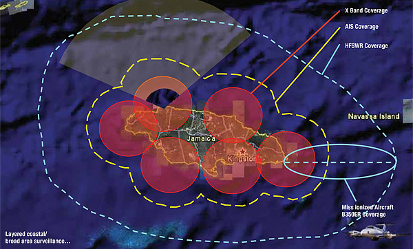
One of the most critical components of effective maritime security is sensors, which need to detect the threat at a sufficient distance to allow adequate reaction time for an effective response. Radar is a critical sensor tool for surveillance which can be mounted on mobile or fixed platforms having varied ranges. They can also be mounted on aircraft which provide maximum flexibility. Fixed systems such as Raytheon’s high frequency surface wave radar provide detection at great distances persistently, but have a significant physical footprint. Coastal radar systems provide excellent surveillance but are limited in range; and depending on the coastal topography, critical gaps in coverage can occur. Thus the best solution for a maritime security is to have a mix of fixed and mobile radar surveillance systems. As a radar cannot carry out identification, cameras are required for this task. Current camera technology allows for ever increasing distances and for weather independent operations.
Analysis/Command and Control
The amount of information available and the number of sensor feeds (i.e. radars, cameras and AIS) far exceed the ability of individuals to deduce useful intelligence for decision-making. The mass of data will only increase as the technology develops. Just as technology provides more information, it needs to assist in interpreting the information through a viable command and control system. Modern command and control systems must be able to carry out the following four actions:
Response
All the sensors and command and control systems will be redundant if adequate response forces are not available for timely reaction. The navy, coast guard and maritime police assets constitute the bulk of a nation’s response capability, thus they should be organised and equipped accordingly.
Consultative Approach
Raytheon adopts a consultative approach for developing any security solution by understanding the nation’s threat and suggests solutions most suited to their environment.
All security issues start with threat and concept of operations (CONOPS). Take the example of the security of a seaport for which the same template is used by examining the security CONOPS of the port, its threats and its vulnerabilities, define the threat, model key steps of the CONOPS, identify gaps and propose solutions to bridge those gaps. The same steps can be applied to land and air threats.
Maritime Protection Process
This involves detection; identification; classification of tracks, including analysis and prioritisation; response to threat; resolution; prediction and deterring.
Current Indian Scenario
Over the past decade, India has begun to address the maritime threats and challenges it faces with the installation of radar systems. But there are significant gaps in the surveillance coverage and the means to integrate local, regional and national information.
Developing India’s Coastal Security
India has started implementing a security system and it is progressing well, but there are still many challenges. Raytheon’s suite of capabilities offers solutions to these challenges as follows: