


The insightful articles, inspiring narrations and analytical perspectives presented by the Editorial Team, establish an alluring connect with the reader. My compliments and best wishes to SP Guide Publications.

"Over the past 60 years, the growth of SP Guide Publications has mirrored the rising stature of Indian Navy. Its well-researched and informative magazines on Defence and Aerospace sector have served to shape an educated opinion of our military personnel, policy makers and the public alike. I wish SP's Publication team continued success, fair winds and following seas in all future endeavour!"

Since, its inception in 1964, SP Guide Publications has consistently demonstrated commitment to high-quality journalism in the aerospace and defence sectors, earning a well-deserved reputation as Asia's largest media house in this domain. I wish SP Guide Publications continued success in its pursuit of excellence.
Deal for the US HawkEye 360 system to India is timely with the ongoing Indo-Pak War, increased Chinese activities in the Indian Ocean Region (IOR) and the anti-India stance of the Bangladesh regime
 |
The Author is Former Director General of Information Systems and A Special Forces Veteran, Indian Army |

Over the past one-year, foreign terrorists killed in Jammu and Kashmir (J&K) have been using satellite phones and navigation systems based on BeiDou, the Chinese satellite system to avoid detection. The terrorists in the Pahalgam massacre, using the banned Huawei satellite phones and encrypted messaging apps, are believed to have maintained contact with their handlers across the border through the Chinese BeiDou satellite system. What sets BeiDou apart is its ability to function completely independent of host infrastructure. These systems enable real-time, high-accuracy navigation in remote terrains where mobile signals are weak or non-existent. BeiDou-enabled devices, including handheld navigation units and satellite communication tools, could allow militants to infiltrate, coordinate, and operate in India without relying on conventional telecom networks. Unlike GPS or mobile towers, BeiDou's Asia-focused architecture offers enhanced accuracy and resilience against jamming.
The terrorists in the Pahalgam massacre, using the banned Huawei satellite phones and encrypted messaging apps, are believed to have maintained contact with their handlers across the border through the Chinese BeiDou satellite system
According to news reports of May 2, 2025, the US has approved the sale of the Hawkeye 360 system having SeaVision software (Maritime Domain Awareness) to India worth $131 million. The HawkEye 360 system will significantly boost India's real-time surveillance capabilities in large maritime areas. The HawkEye 360 system deal includes radio frequency (RF) sensors, analytics software, system integration support and training modules. The HawkEye 360 is a swarm of small satellites in Low-Earth Orbit (LEO) that can track radio frequency (RF) signals emanating from ships, aircraft, vehicles, and naval systems. The HawkEye 360 system can also capture radio frequency emissions from ships that have turned off their transponders, making it an invaluable tool in maritime surveillance.

HawkEye 360's Electro Optical (EO) imaging provides RF-based location of ships by capturing high-resolution images of vessels during daytime, which are then analysed by human analysts for RF detections. Its IR sensors detect ships using their heat signature from engines and exhaust, which is helpful in tracking stealthy ships at night. The state-of-the-art satellite system works as the RF layer in a larger ISR system, and has additional layers such as electro-optical (EO), infrared (IR) and synthetic aperture radar (SAR), each working in unison or independently to detect, confirm and classify threats. The capabilities of HawkEye 360 can be enhanced using multi-layered surveillance such as ground-based and sea-based surveillance systems, providing a virtual 360 surveillance capability to the operator. Deal for the HawkEye 360 system to India is timely with the ongoing Indo-Pak War, increased Chinese activities in the Indian Ocean Region (IOR) and the anti-India stance of the Mohammad Yunus-led Bangladesh regime. Hopefully, induction of the HawkEye 360 system into the Indian Navy would not take many months/years.
The HawkEye 360 system can also capture radio frequency emissions from ships that have turned off their transponders, making it an invaluable tool in maritime surveillance
Concurrently, news reports (before the launch of Operation 'Sindoor') had stated that the Indian Air Force (IAF) is seeking to bolster its surveillance capabilities by acquiring three High-Altitude Platform System (HAPS) unmanned aircraft; with these unmanned 'pseudo-satellites' operating in the stratosphere, providing continuous real-time intelligence, surveillance, and reconnaissance (ISR). HAPS aircraft, which are usually solar-powered, are considered much cheaper to deploy and operate. HAPS can deploy and operate automatically; they do not require launch vehicles like satellites. They can be deployed from different locations as well as repaired and maintained easily compared to satellites.

The IAF wants these HAPS unmanned aircraft operating at an altitude of about 20-km, which is much higher than the flight path of commercial aircraft. These HAPS aircraft will be used for continuous ISR, as well as acting as an airborne data relay for other airborne unmanned platforms for electronic and communication intelligence. Initiating the case for the unmanned HAPS aircraft and associated equipment, the IAF has issued an initial Request for Information (RFI) for vendors to submit their responses by June 20, 2025.
Indian Air Force (IAF) is seeking to bolster its surveillance capabilities by acquiring three High-Altitude Platform System (HAPS) unmanned aircraft
The RFI states these HAPS unmanned aircraft to have a minimum operational endurance of 48 hours, with data links and telemetry range of at least 250 km in a line-of-sight environment, and the satellite communication (SATCOM) range of at least 400 km. The RFI further lays down the following: detection range of at least 50 km from the operating altitude; should be compatible with EO and IR cameras as well electronic and communication intelligence payloads; capable of effectively operating by night and low-visibility conditions; complete delivery to be completed within 18 months of signing the contract.
Separately, the IAF is also pursuing a case for three intelligence, surveillance, targeting and reconnaissance (ISTAR) aircraft to provide accurate actionable intelligence acquired through synthetic aperture radars, electro-optical and infrared sensors. Also, the launch of 52 military satellites in a decade under Phase III of the Space Based Surveillance (SBS-III), approved by the Cabinet Committee on Security (CCS) on October 8, 2024 was covered in these columns earlier. The Armed Forces are, therefore, pursuing the case for launch-on-demand satellites.
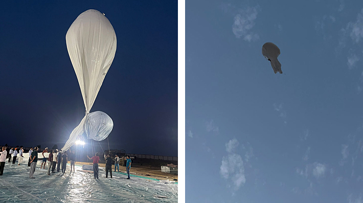
On May 3, 2025, the Defence Research and Development Organisation (DRDO) successfully carried out maiden flight-trials of the Stratospheric Airship Platform
On May 3, 2025, the Defence Research and Development Organisation (DRDO) successfully carried out maiden flight-trials of the Stratospheric Airship Platform from Sheopur in Madhya Pradesh. Developed by Aerial Delivery Research and Development Establishment, Agra, the airship carried its instrumental payload to an altitude of around 17 km. Data from onboard sensors was received and would be utilised for development of high-quality fidelity simulation models for future high-altitude airship flights. Envelope pressure control and emergency deflation systems were deployed in flight for their performance evaluation. Trial team recovered the system for further investigation. The total duration of the flight was about 62 minutes. Defence Minister Rajnath Singh has congratulated the DRDO and stated that this system will uniquely enhance India's earth observation and ISR capabilities, making the country one of the few countries in the world having such indigenous capabilities.